Maps as Text - Printing Press and Reformation
Anne Raybon
20 Followers
Grade Levels
7th - 9th
Resource Type
Standards
CCSSRH.6-8.1
CCSSRH.6-8.6
CCSSRH.6-8.7
Formats Included
- Publisher files
Pages
4 pages
Anne Raybon
20 Followers
What educators are saying
Since I teach a combined World History and Geography course, this activity was perfect to reinforce the content for my unit on the Reformation while also practicing map-reading skills.
Description
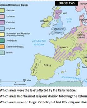
Includes 4 maps: modern Europe for reference; Europe prior to the Reformation; religious division in Europe following the Reformation; and the growth and locations of printing presses.
Questions ask students to analyze and infer, and to draw conclusions from the maps.
This should be printed in color--laminate for use year-to-year.
Questions ask students to analyze and infer, and to draw conclusions from the maps.
This should be printed in color--laminate for use year-to-year.
Total Pages
4 pages
Answer Key
N/A
Teaching Duration
N/A
Report this resource to TPT
Reported resources will be reviewed by our team. Report this resource to let us know if this resource violates TPT’s content guidelines.
Standards
to see state-specific standards (only available in the US).
CCSSRH.6-8.1
Cite specific textual evidence to support analysis of primary and secondary sources.
CCSSRH.6-8.6
Identify aspects of a text that reveal an author’s point of view or purpose (e.g., loaded language, inclusion or avoidance of particular facts).
CCSSRH.6-8.7
Integrate visual information (e.g., in charts, graphs, photographs, videos, or maps) with other information in print and digital texts.


